
Harpers Ferry and the View from Maryland Heights

Maryland Heights is a popular 4.5-mile hike at Harpers Ferry National Historic Park. It’s located on Massawomeck land. Photo courtesy of author
Harpers Ferry is a 3,500-acre National Historic Park located in West Virginia, Maryland and Virginia. At just over an hour away from Washington DC and Baltimore, it is the perfect spot to day hike along the Appalachian Trail or bike along the 184-mile Chesapeake & Ohio canal path.
There are many reasons to visit but one of my favorites is the Maryland Heights trail.
The 4.5-mile hike begins in the cobbled streets of historic Lower Town. After crossing the Potomac River, the route follows the C&O Canal towpath before arriving at the trailhead and heading uphill for the next two miles. Pretty simple right?
At the top, Maryland Heights offers a scenic view of Lower Town and—if you’re lucky—a CSX train thundering its way across the railroad bridge far below. You can also literally see where the Potomac and Shenandoah rivers meet. It’s absolutely breathtaking.
Sometimes, the boulders along the edge of the overlook are cordoned off due to peregrine falcon nesting or mating in the area. Don’t worry, you can still snap the perfect photo for the family group chat or your online dating profile (I’ve done both!) from a little farther back. The falcons appreciate our sacrifice and we love to have them around! They really are truly beautiful to behold as they soar along currents of air on a warm day.
Here are some things you should know about the hike:
Rail Bridge
Part of the appeal of the hike is crossing the footbridge that runs alongside the railroad connecting Harpers Ferry, West Virginia and Sandy Hook, Maryland. Quite a few people cross the bridge to hike the Maryland Heights Trail, or bike along the Chesapeake and Ohio Canal—another National Historical Park popular with cyclists—or to thru-hike the 2,180-mile Appalachian Trail which runs through Harpers Ferry on its way from Georgia to Maine.
The bridge is a special part of the park—so much so that hiking ground to a halt after a Dec 2019 train derailment left thru-hikers and tourists scrambling for ways to safely cross the Potomac. Fortunately, CSX finished construction of the new footbridge in July 2020.
There’s a lot to do and see in Harper’s Ferry in addition to the Maryland Heights Trail. Just remember whose land you’re on, and the fact that this gorgeous National Park, originally designated as a national monument in 1944, would not have been possible without the displacement and genocide of Indigenous people like the Massawomeck.

Maryland Heights offers 180-degree views of Lower Town, Harpers Ferry as well as the Potomac and Shenandoah Rivers. (Photo courtesy of author)
History of the Town
Harpers Ferry is located on Massawomeck ancestral land. They were longhouse builders and members of the powerful Haudenosaunee confederacy which reached western Maryland and West Virginia. Very little information about the Massawomeck exists beyond 1635.
The town’s namesake is Robert Harper, who established a ferry in 1747 to transport settlers across the Potomac. The government added an armory and arsenal around 1800.
Meanwhile, construction of the C&O canal began in Washington DC in 1828 and finally reached Harpers Ferry in 1834. The C&O became a useful way to transport agricultural goods from farm to market, however, it was quickly overtaken by the expansion of the railroad. The Baltimore and Ohio Railroad built the Potomac River crossing in 1839. It was destroyed during the Civil War and rebuilt, along with a rail tunnel, in 1894.
The town is probably best known as the site of the ill-fated 1859 anti-slavery revolt by white abolitionist John Brown (fun fact: both Frederick Douglass and Harriet Tubman were invited but declined to attend because…reasons). Several Civil War battles and skirmishes also occurred in and around the town.
Where to park
It costs $20 per vehicle to park at the Harpers Ferry Visitors Center, or $35 for an annual pass. Military veterans get in free. The location is 171 Shoreline Dr, Bolivar, WV 25425. The Visitor Center has a few hundred parking spots but it does fill up during the summer! The shuttle runs from 9 am until approximately 5:30 p.m. Shuttle service runs a little later (until 6:45 pm) during the summer. Current shuttle capacity may be limited due to Covid so be prepared to wait. The alternative is to find a space in the small public parking lot at the intersection of Shenandoah and Shoreline Drive. It fits around 20 vehicles, but on the weekends that fills up long before the park opens, with AT day hikers.
Currently, there is no legal parking available on the Maryland side near the trailhead.
Hours of Operation
The park is open year round with the exception of Thanksgiving, Christmas and New Year’s Day. During the winter, the museums and exhibits are open from 9 a.m. - 5 p.m. Summer hours of operation are from 9 a.m. - 6 p.m. The trails are open from sunrise to sunset. Check the website before you go for up-to-date operating hours, closures and shuttle information.

Mudslides and floodwaters sometimes necessitate trail and park closures. Here, rising water levels partially obscure the ruins of the old Baltimore & Ohio railroad bridge in this 2018 photo (Photo courtesy of author).
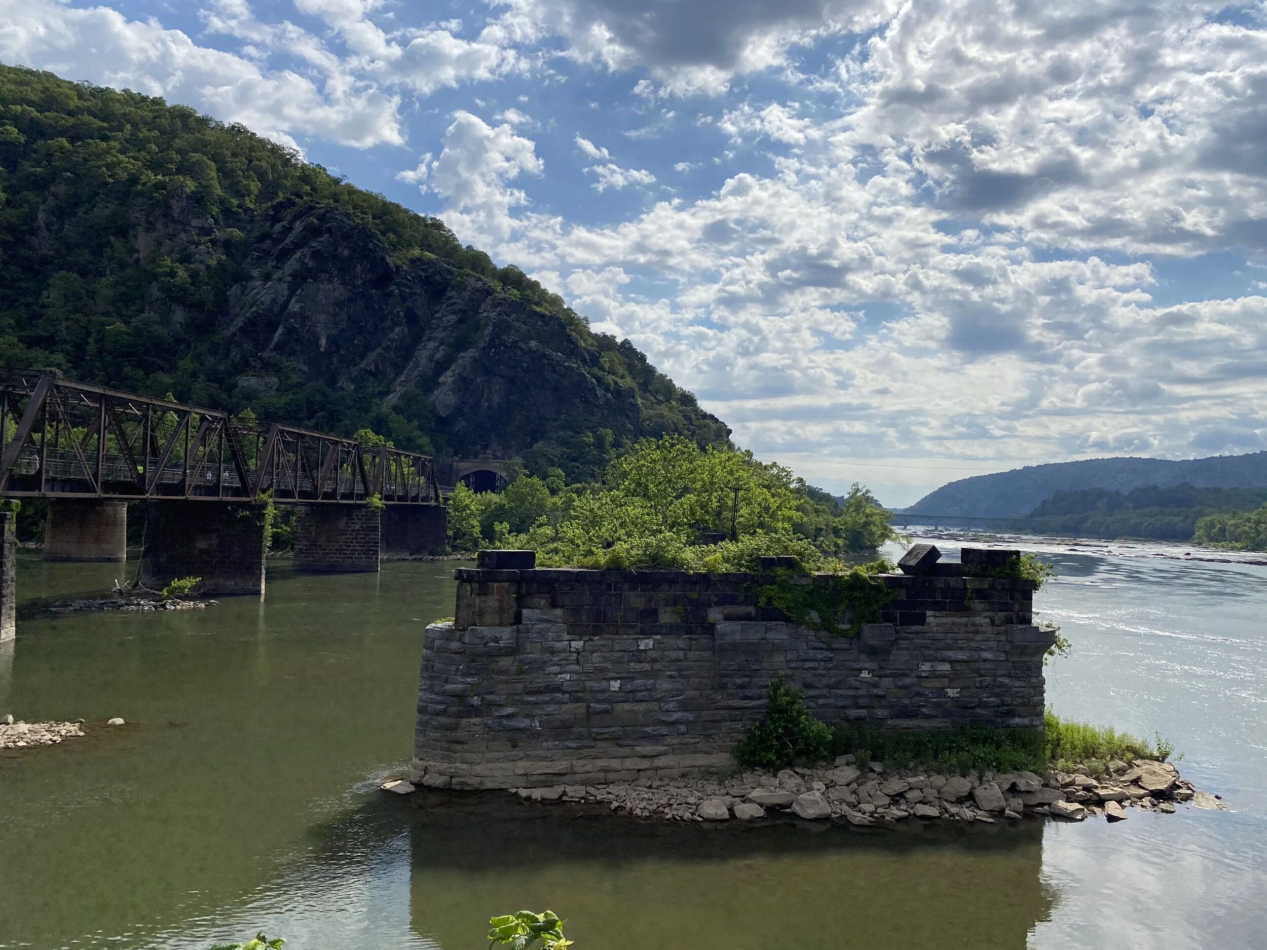
The same stone pier is visible under regular conditions in 2020 (Photo courtesy of author).
Park Amenities
There are no public trash cans, water stations or bathrooms in the park other than the ones at the Visitor Center (which don’t have automatic entrances). This lowers overall accessibility of the park which receives up to 300,000 visitors a year according to The Washington Post. If you’re looking for a restroom in Lower Town, there are a few bathrooms available to paying customers at some of the cafés, like The Coffee Mill. Once you leave Lower Town, you will have to make do with what you can carry—that includes water. Please bring your own water source or purchase water before you begin your hike!

Since 2019, Harpers Ferry has lacked waste receptacles, which makes this park a logistical challenge for disabled folks or anyone who might actually benefit from a public trashcan. (Photo courtesy of author)
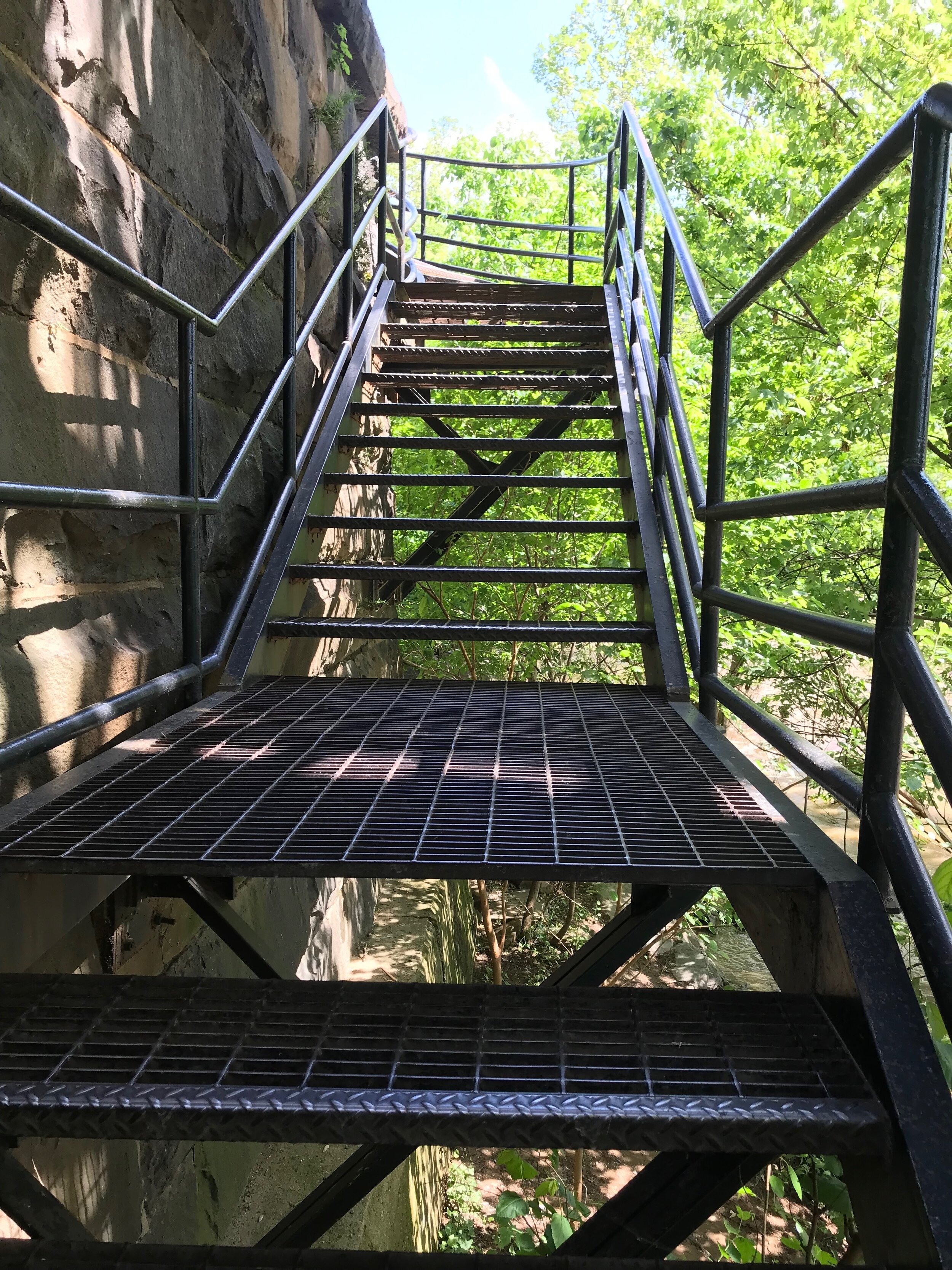
Stairs on the canal side of the bridge. (Photo courtesy of author)
Mobility
The streets of Lower Town are hilly and cobblestoned with narrow sidewalks and few curb cuts. Lower Town is not super accessible for wheelchair users.
Theres an area in Lower Town next to the bridge on the WV side called The Point which includes a grassy area with lovely views of both rivers. It is accessible via a short, steep gravel path.
Unfortunately, the gravel isn’t well compacted, it’s very loose. I have a hard time walking in gravel with my elbow crutches so I usually cut through the grass to get to The Point. I couldn’t imagine doing either in a wheelchair. It’s not clear why the path hasn’t been paved, especially since the flat overlook offers a beautiful view of the bridge, and the two rivers—no hiking required. It should be wheelchair accessible—it just isn’t for some reason.

This flat overlook in Lower Town is called the Point! It is perfect for picture taking! In a more disability-friendly version of the park, this would be paved and wheelchair accessible so more of the 300,000 people who visit annually can fall in love with this beautiful spot. (Photo courtesy of author)

The Point where the Shenandoah and Potomac Rivers meet (Photo courtesy of author)
To get to the Maryland Heights trail from Lower Town, you have to cross the Goodloe E. Byron Memorial Pedestrian Walkway that runs parallel to the CSX railroad bridge. On the opposite side of the Potomac, you must descend a spiral staircase to get to the C&O Canal towpath. If you have trouble with steps an alternative would be to park on the Maryland side along the C&O Canal however parking on that side has been restricted so check before you go. The bridge gets crowded, however, people cross at different paces carrying everything from kids to dogs (the bridge surface gets hot in the summer) to bikes, so don’t sweat it!
The Maryland Heights trail is extremely rocky, steep and uneven due to water drainage. It’s an out-and-back trail that is almost entirely uphill. Closer to the overlook, there’s a series of short switchbacks that descend to the overlook. However, the majority of the hike is uphill, so bring your mobility aids, AFOs and braces!
For more information on accessibility for the entire park, visit their website.
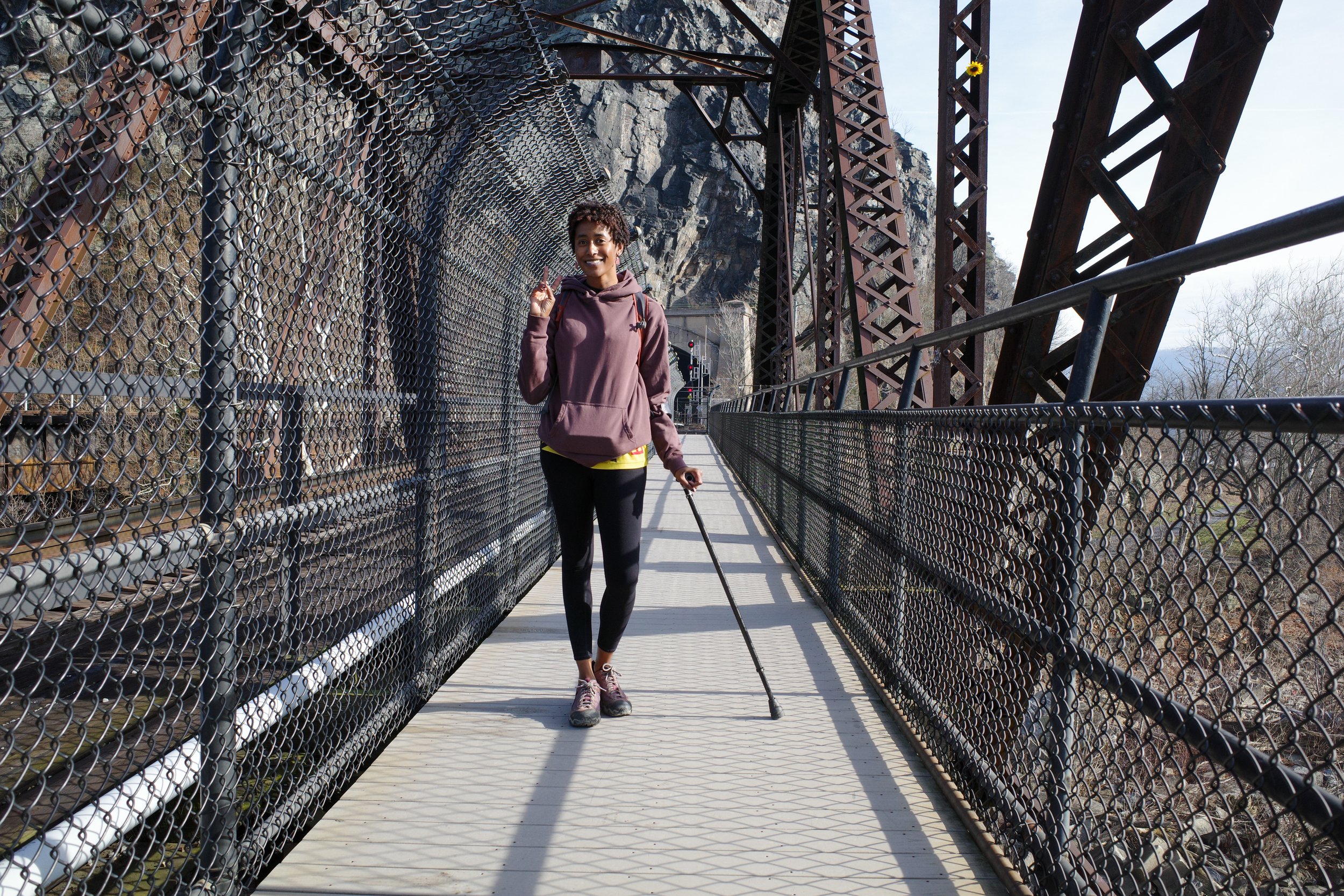
The railroad tunnel and the current railroad bridge were built in 1894 after the 1851 bridge was destroyed several times during the Civil War. The footbridge was destroyed again in Dec 2019 after a freight train derailed. The footbridge re-opened to the public in July 2020. (Photo courtesy of author)
Difficulty level
Since most of the hike takes place on a steep incline; it can feel mentally exhausting. Every bend in the trail leads to another soul-crushing rocky slope. The Maryland Heights Trail can seem never-ending, but it’s actually a beautiful immersive nature walk once you get to know it. So instead of checking Harpers Ferry off your list, I highly recommend you come back and visit a few times! Not only will the hike get easier but there are plenty of other trails to check out in the area, along with shops, museums, battlefields and more.
Dogs
Weekends in-season are busy! Especially later in the day and especially if the weather is fair. There are a lot of dogs on the Maryland Heights Trail, most are leashed in accordance with park rules but some are off-leash.

Resting atop a large boulder on the bank of the Potomac River (Photo courtesy of author).
Water
Water is everywhere at this park! That’s one reason why I love it. There’s the comforting sound of the Shenandoah and Potomac rivers which heightens to a crescendo during flood season. You’ll know it when you see it and hear it. The water changes colors due to sediment and soil and some of your favorite sights slip below its murky surface. Also, the flood waters don’t flow, they thunder.
There are a few spots where you can rest on boulders close to the river’s edge and lie barefoot on a warm day to watch people float past in large inner tubes. Just don’t do this during flood season.
Then there’s the trickle of runoff from culverts along the Maryland Heights Trail - especially after a rain. Far below the trail, there’s a stream that adds to the cacophony of running water. On my way back to Lower Town from the Overlook, hearing the sound of water lets me know I don’t have too far to go! So much natural beauty to enjoy, oh, but if you’re looking for a water station it doesn’t exist beyond the parking lot, so bring your own water or purchase a water bottle in Lower Town before you begin your hike.

Only two switchbacks to go before you reach the end of the Maryland Heights trail; or two miles to go before you reach Lower Town (Photo courtesy of author).

Whitewater eddies and cascades over partially submerged boulders in the Potomac River. This is what the river looks like during winter. During summer it’s usually full of people kayaking or floating along in inner tubes. (Photo courtesy of author)
Masks & Social Distancing
This popular trail can get pretty crowded in-season. People naturally space out along the hike but it gets more congested as you get closer to the overlook. Thats because the path gets progressively narrower and rockier, causing people to naturally converge.
I’ve hiked this trail many times over the past five years. Most people do not wear masks so if you’re looking for a more socially-distanced hike, check out the Stone Fort connector trail for an overall 6-mile hike. The view isn’t as majestic, however, it’s a quieter walk. Or try this hike out-of-season. You can also plan to arrive between sunrise when the trail officially opens and 9 a.m. when the park opens. If you plan on arriving early, park in the small lot at the intersection of Shenandoah St. and Shoreline Dr. and add another 1.6 miles (there-and-back) to your hike. Please visit their website and double check that this lot is open before you go!
Thanks for reading! If you have any Harpers Ferry or Maryland Heights Trail recommendations, let us know in the comments below.


In the United States, public lands are accessible to everyone, in theory—but only if you know the inside baseball. This article breaks down the four largest federal public land managers, plus three more you probably haven’t heard of, so you can get outside with family and friends this summer.